Sunday, April 29, 2012
Disaster Assistance - Today's Forecast
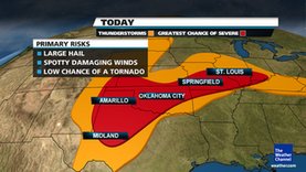
A stalled-out frontal boundary from the mid-Mississippi Valley to the Southern Plains will serve as the focus for scattered severe thunderstorms the next few days. While large hail and damaging winds remain the primary threat, isolated tornadoes are also possible.
Sunday's Thunderstorm Forecast
The outlined red area is where we are forecasting the greatest chance of severe weather. Orange indicates areas of general thunderstorms that remain below the severe threshold.

Subscribe to:
Post Comments (Atom)

No comments:
Post a Comment