Thursday, April 29, 2010

Wednesday, April 28, 2010


Tuesday, April 27, 2010

Monday, April 26, 2010




Sunday, April 25, 2010
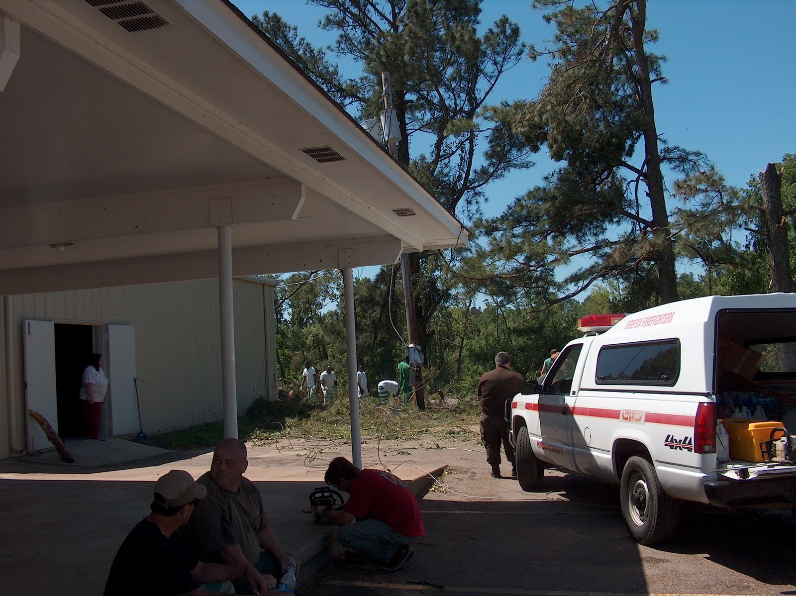
Arrived at Yazoo City Church of Christ
We are already serving lunches and taking them out into other areas. The church had some damage to roof. The parking lot is full of ele utility trucks putting up new lines. I have photos but my connection here is very bad will upload photos later.
Saturday Storms
Severe storms sent tornadoes across the state Saturday afternoon, killing at least 10. But Yazoo County was the epicenter of the wreckage. Four people died and at least 31 were injured in the county north of Jackson.
The tornado that hit the county around Yazoo City at noon left a swath of damage miles long, reducing churches, businesses and homes to splinters. The tornado moved northeast across the state, causing damage in several other counties. Five people were killed in Choctaw County; another died in Holmes County.
The wounded were taken by ambulance to area hospitals and at least two were airlifted by helicopter to the University of Mississippi Medical Center in Jackson.
State highway patrolmen blocked the highway into Yazoo City allowing access only to residents. And the Mississippi National Guard deployed 40 guardsmen to the city to prevent looting and help with damage assessment.
Throughout residential neighborhoods, officials and volunteers with chainsaws cut away trees that still blocked roads so rescue workers could continue searching properties into the night.
"We still have people trapped in houses and cars," Gov. Haley Barbour said during an impromptu press conference in front of the Ribeye's Steak and Seafood, a demolished restaurant.
The governor became teary describing the damage done to his hometown.
"This was enormous. It reminds me of (Hurricane) Katrina," he said.
Barbour declared 17 counties to be in a state of emergency and toured the damaged areas in a National Guard helicopter, said Jeff Rent, spokesman for the Mississippi Emergency Management Agency.
The tornado that hit the county around Yazoo City at noon left a swath of damage miles long, reducing churches, businesses and homes to splinters. The tornado moved northeast across the state, causing damage in several other counties. Five people were killed in Choctaw County; another died in Holmes County.
The wounded were taken by ambulance to area hospitals and at least two were airlifted by helicopter to the University of Mississippi Medical Center in Jackson.
State highway patrolmen blocked the highway into Yazoo City allowing access only to residents. And the Mississippi National Guard deployed 40 guardsmen to the city to prevent looting and help with damage assessment.
Throughout residential neighborhoods, officials and volunteers with chainsaws cut away trees that still blocked roads so rescue workers could continue searching properties into the night.
"We still have people trapped in houses and cars," Gov. Haley Barbour said during an impromptu press conference in front of the Ribeye's Steak and Seafood, a demolished restaurant.
The governor became teary describing the damage done to his hometown.
"This was enormous. It reminds me of (Hurricane) Katrina," he said.
Barbour declared 17 counties to be in a state of emergency and toured the damaged areas in a National Guard helicopter, said Jeff Rent, spokesman for the Mississippi Emergency Management Agency.
Saturday, April 24, 2010
Mississippi Tornado
Hi Everyone
As soon as I finish unhooking power and filling up water tank, I will be in the mobile
headquarters headed towards Mississippi. Sounds like there has been extensive
damage there. I have talked to Meadowbrook Church of Christ in Jackson Ms and
they tell me that the roads are blocked to Yazoo City except for police and emergency
vehicles. I should be there tomorrow to access the needs and go to work.
Our funds are very low. We need your help to purchase food and supplies to help our
neighbors in Mississippi.
As soon as I finish unhooking power and filling up water tank, I will be in the mobile
headquarters headed towards Mississippi. Sounds like there has been extensive
damage there. I have talked to Meadowbrook Church of Christ in Jackson Ms and
they tell me that the roads are blocked to Yazoo City except for police and emergency
vehicles. I should be there tomorrow to access the needs and go to work.
Our funds are very low. We need your help to purchase food and supplies to help our
neighbors in Mississippi.
Tuesday, April 20, 2010
Friday, April 16, 2010


Friday, April 9, 2010
Wednesday, April 7, 2010
2010 Hurricane Season
The Atlantic basin could be in for an above-average hurricane season this year with four major hurricanes forecast to develop in the region, according to forecasters at Colorado State University.
The forecast team of William Gray, who has led the forecast team for 27 years, and Phil Klotzbach, lead forecaster on the university hurricane forecast team, released their predictions for the 2010 hurricane season, running June 1 to Nov. 30.
The team predicts 15 named storms will form in the Atlantic. Eight are expected to become hurricanes, and four will develop into major hurricanes—Category 3, 4, or 5 on the Saffir-Simpson scale, with sustained winds of 111 mph or more.
“We expect current moderate El Nino conditions to transition to neutral conditions by this year’s hurricane season,” Mr. Klotzbach said in a statement. “The dissipating El Nino, along with the expected anomalously warm Atlantic ocean sea surface temperatures, will lead to favorable dynamic and thermodynamic conditions for hurricane formation and intensification.”
Mr. Gray said the probability of a major hurricane making landfall along the U.S. coastline “is 69 percent compared with the last-century average of 52 percent. While patterns may change before the start of hurricane season, we believe current conditions warrant concern for an above-average season.”
The team said current weather conditions have a number of similarities to early April conditions that preceded the hurricane years of 1958, 1966, 1969, 1998 and 2005. All five of these seasons had above-average activity, especially the seasons of 1969, 1998 and 2005, the team said.
The team predicts tropical cyclone activity in 2010 will be 160 percent of the average season. By comparison, 2009 witnessed tropical cyclone activity that was about 70 percent of the average season.
The hurricane forecast team’s probabilities for a major hurricane making landfall on U.S. soil are as follows:
• A 45 percent chance that a major hurricane will make landfall on the U.S. East Coast, including the Florida Peninsula (the long-term average is 31 percent).
• A 44 percent chance that a major hurricane will make landfall on the Gulf Coast from the Florida Panhandle west to Brownsville (the long-term average is 30 percent).
• A 58 percent chance of a major hurricane tracking into the Caribbean (the long-term average is 42 percent).
The team said it will issue forecast updates on June 2 and Aug. 4.
The forecast team of William Gray, who has led the forecast team for 27 years, and Phil Klotzbach, lead forecaster on the university hurricane forecast team, released their predictions for the 2010 hurricane season, running June 1 to Nov. 30.
The team predicts 15 named storms will form in the Atlantic. Eight are expected to become hurricanes, and four will develop into major hurricanes—Category 3, 4, or 5 on the Saffir-Simpson scale, with sustained winds of 111 mph or more.
“We expect current moderate El Nino conditions to transition to neutral conditions by this year’s hurricane season,” Mr. Klotzbach said in a statement. “The dissipating El Nino, along with the expected anomalously warm Atlantic ocean sea surface temperatures, will lead to favorable dynamic and thermodynamic conditions for hurricane formation and intensification.”
Mr. Gray said the probability of a major hurricane making landfall along the U.S. coastline “is 69 percent compared with the last-century average of 52 percent. While patterns may change before the start of hurricane season, we believe current conditions warrant concern for an above-average season.”
The team said current weather conditions have a number of similarities to early April conditions that preceded the hurricane years of 1958, 1966, 1969, 1998 and 2005. All five of these seasons had above-average activity, especially the seasons of 1969, 1998 and 2005, the team said.
The team predicts tropical cyclone activity in 2010 will be 160 percent of the average season. By comparison, 2009 witnessed tropical cyclone activity that was about 70 percent of the average season.
The hurricane forecast team’s probabilities for a major hurricane making landfall on U.S. soil are as follows:
• A 45 percent chance that a major hurricane will make landfall on the U.S. East Coast, including the Florida Peninsula (the long-term average is 31 percent).
• A 44 percent chance that a major hurricane will make landfall on the Gulf Coast from the Florida Panhandle west to Brownsville (the long-term average is 30 percent).
• A 58 percent chance of a major hurricane tracking into the Caribbean (the long-term average is 42 percent).
The team said it will issue forecast updates on June 2 and Aug. 4.
Friday, April 2, 2010
Had a great 3 days at Lake Jackson, TX Church of Christ. Wed night had 60+ for dinner than a very good meeting with the Elders. I have arrived in El Campo, TX. Going to a crawfish cook at one of the Elders home tonight and a BBQ Easter party at another one of the Elders tomorrow. Will keep you updated.
Monday, March 29, 2010
Lake Jackson Church of Christ
From the Tulsa Workshop I came on down to Texas. My first stop was Lake Jackson CoC. I arrived here Sunday afternoon and attended services with them that evening. I will be cooking them one of our Disaster meals Wednesday before service than have a meeting with the Elders after the meal. On Thursday I will be heading to El Campo. I will be there about a week. Jane and Judy's family have a lake with rv hookup. They have invited me to stay there and have Easter with them and than cook our Disaster meal and speak at the El Campo Church of Christ the following Wednesday. I plan on spending the month of April here in Texas visiting some of the churches that worked with us during Ike.
Thursday, March 25, 2010

Tuesday, February 23, 2010
We are now preparing for the 2010 storm season(floods, tornados and hurricanes) below is the hurricane prediction for this year
The hurricane season forecast from Colorado State University's Tropical Meteorology Project predicts above-average activity in the Atlantic for 2010 beginning June 1st.
The 2010 hurricane season is predicted to be more active than the average for the 1950-2000 seasons. The December 2009 report estimates approximately 11-16 named storms, 6-8 hurricanes and 3-5 major hurricanes occurring during the 2010 Atlantic hurricane season, which is more typical of years in an active era, such as the 1995 season.
The forecast utilizes a statistical methodology derived from 58 years of past data and climate-related global and regional predictors. The effects of El Nino or La Nina also have an impact on the frequency of hurricanes. El Nino creates warmer water, and stronger winds that rip tropical depressions apart before they become tropical storms or hurricanes. La Nina creates cooler water, resulting in more hurricanes. Based on these facts, it is forecasted that El Nino conditions now in effect will weaken.
Importance of Hurricane Season Forecasts
The early forecast for the 2010 Atlantic Hurricane Season issued in December can be seen as a good estimate of future storm activity. The scientists at Colorado State University are hesitant to release actual storm number predictions until April 2010. Yet, this December 2009 report aims to “satisfy the curiosity of the general public and to bring attention to the hurricane problem.” This is the 27th year that the Colorado State University Tropical Meteorology Project has released a hurricane season forecast.
Due to the fact that previous December forecasts have yet to show a satisfactory forecast skill, the December reports only issue a range of numbers and an assessment of current conditions. This assessment provides the background for the forecast in determining the likely conditions for Atlantic basin tropical cyclone presence. The specific numbers will not be issued until early April 2010.
New Statistical Forecasts More Accurate
The CSU Tropical Meteorology Project scientists state that “we have yet to demonstrate real-time forecast skill for our early December forecasts that have been issued for the last 18 years”. However, the team is now utilizing a new statistical forecast methodology for our early December predictions, in hopes of increasing the skill and accuracy of the report.
The 2010 hurricane season is predicted to be more active than the average for the 1950-2000 seasons. The December 2009 report estimates approximately 11-16 named storms, 6-8 hurricanes and 3-5 major hurricanes occurring during the 2010 Atlantic hurricane season, which is more typical of years in an active era, such as the 1995 season.
The forecast utilizes a statistical methodology derived from 58 years of past data and climate-related global and regional predictors. The effects of El Nino or La Nina also have an impact on the frequency of hurricanes. El Nino creates warmer water, and stronger winds that rip tropical depressions apart before they become tropical storms or hurricanes. La Nina creates cooler water, resulting in more hurricanes. Based on these facts, it is forecasted that El Nino conditions now in effect will weaken.
Importance of Hurricane Season Forecasts
The early forecast for the 2010 Atlantic Hurricane Season issued in December can be seen as a good estimate of future storm activity. The scientists at Colorado State University are hesitant to release actual storm number predictions until April 2010. Yet, this December 2009 report aims to “satisfy the curiosity of the general public and to bring attention to the hurricane problem.” This is the 27th year that the Colorado State University Tropical Meteorology Project has released a hurricane season forecast.
Due to the fact that previous December forecasts have yet to show a satisfactory forecast skill, the December reports only issue a range of numbers and an assessment of current conditions. This assessment provides the background for the forecast in determining the likely conditions for Atlantic basin tropical cyclone presence. The specific numbers will not be issued until early April 2010.
New Statistical Forecasts More Accurate
The CSU Tropical Meteorology Project scientists state that “we have yet to demonstrate real-time forecast skill for our early December forecasts that have been issued for the last 18 years”. However, the team is now utilizing a new statistical forecast methodology for our early December predictions, in hopes of increasing the skill and accuracy of the report.
Saturday, February 20, 2010
Haiti Update From WFRRM
Dave Heath I think I know why I am here. I Made another connection with to 2 more hospitals and 2 orphanages. They care for the wounded orphans after the Milo hospital gets done with the critical care portion. They need food so we will provide. Got a pilot to pick up beans in the DR for $50.00 a bag and they will arrive today. Th...at is a $17.00 savings per bag. "I AM" is making it all happen among the NGO's we are talking and networking like I have never seen happen before. I put This new girl in touch with another hospital and they needed beds and the other hospital had them. Wow I would have never thought like this before. While typing this a nurse came up and asked me if I do food and I said yes. She said she is leaving and has some anitbiotics to give away. All the sudden one of the doctors I know came by and I introduced them to each other and he was looking for anitbiotics. Gee what acoincidence - RIGHT!
Subscribe to:
Posts (Atom)
